TURN 4 TERRACE

2027 SPRING NASCAR WEEKEND
SPRING WEEKEND: Saturday, May 8 - Sunday, May 9
2027 FALL NASCAR WEEKEND
FALL WEEKEND: October 1-3, 2027
Need help building your experience? Schedule a call and get personalized support.

FACILITY MAPS

This map shows the layout of RV and terrace parking areas located within and around the oval track at Kansas Speedway. The map is oriented with north at the top and includes designated zones for RV camping, terrace parking, and accessibility support.
Key Areas and Features
Infield Area:
-
Infield Reserved: Centrally located within the racetrack's interior. This area is surrounded by RV parking spaces arranged in rows, identified with 1000-, 2000-, and 3000-level numbers.
-
Front Runners, Speedway Club, and Terrace zones are centered in the infield and provide premium access and amenities. These are designated in a gray box.
-
ADA Campsites: Accessible sites are available within the infield. Guests can call 866-460-7223 for ADA assistance.
Terrace Parking Zones (Outside the Track Oval):
-
Turn 1 Terrace: Located at the southeast curve of the oval.
-
Turn 3 Terrace: Located at the northwest curve.
-
Turn 4 Terrace: Located at the northeast curve.
-
Backstretch Terrace: Runs along the long straight section on the far side of the oval, opposite the main grandstands.
Other Camping Areas (Visible in Mini-Map Overview at Top Right)
-
Phoenix Campground, Daytona Blue Lot, and Daytona White Lot: East side of the speedway.
-
Richmond Camping and Martinsville Campground: Southwest and northwest, respectively.
-
Tent Camping Campground: Located near Turn 1, for non-RV guests.
Roadways and Layout
-
The map includes labeled turns (Turn 1 through Turn 4) for orientation.
-
RV parking rows are labeled numerically and organized into color-coded blocks.
-
The racetrack oval forms a ring around the infield RV sites, with terrace RV lots positioned along the outer perimeter of each turn and the backstretch.
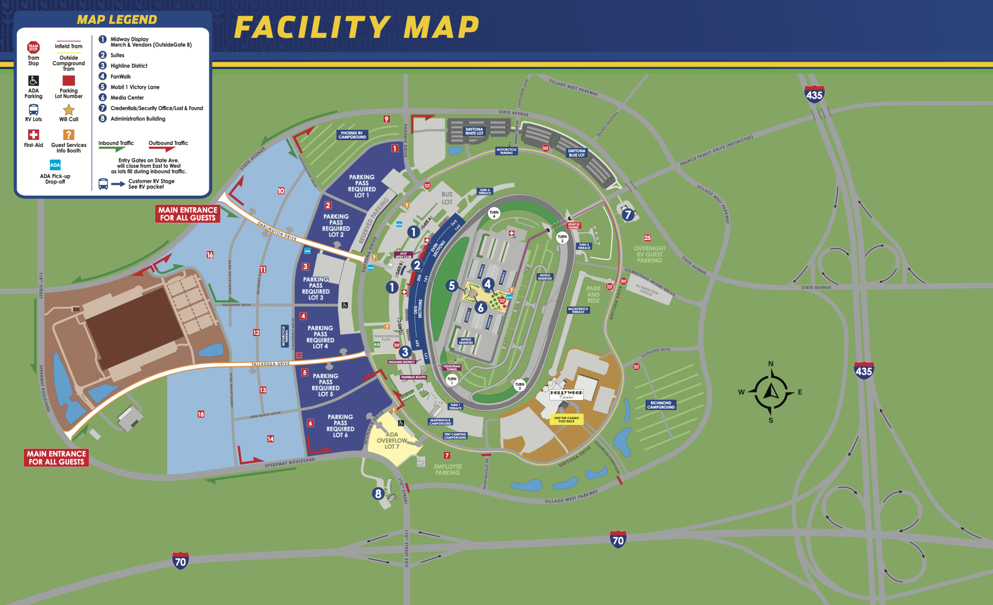
Map Overview
The map shows the full Kansas Speedway campus layout for the 2026 Fall event, including roads, entry points, parking areas, campgrounds, grandstands, tram stops, and key fan and operational facilities.
Main Roads & Surrounding Streets
-
Key surrounding roads: State Avenue, Village West Parkway, 110th Street, Prairie Crossing, Stadium Parkway
-
Internal roadways: France Family Drive (restricted), Speedway Boulevard, California Drive, Chicagoland Drive, Homestead-Miami Drive, and others named after NASCAR tracks
-
One-way roads and vehicle tunnel access are marked
-
Main guest entrance is located off State Avenue
Entrances & Entry Gates
-
Multiple entry gates along State Avenue, labeled Gate A, B, and C
-
Entry gates close east to west as lots fill
-
Vehicle entrance for casino marked as one-way only
-
Credential office and security near the Administration Building
Parking Areas
-
Numbered lots (Lots 1–7) require parking passes
-
ADA parking is labeled and located near tram stops and entrances
-
Employee parking, overnight RV guest parking, and motorcycle parking are designated
-
Park and Ride area and RV Inspection Station are located on the periphery
Campgrounds & RV Areas
-
Labeled campgrounds include:
-
Martinsville Campground (outside)
-
Tent Camping Campground
-
Phoenix RV Campground
-
Richmond Campground
-
-
Infield Reserved RV
-
Turn 1, 3, and 4 Terraces
-
Backstretch Terrace
-
Daytona Blue Lot and White Lot
Fan Zones & Amenities
-
FanWalk
-
Ally Apex Club near Turn 2
-
Mobil 1 Victory Lane
-
Highline District pedestrian zone
-
Merch & Vendor booths near Gate B
-
Guest Services and Info Booths marked with a question mark symbol (?)
-
First Aid and Lost & Found are labeled
Transportation
-
Multiple tram stops inside and outside the venue
-
Infield tram service noted
-
Transportation Plaza near RV guest parking
Track Reference Points
-
Turns 1 through 4 are marked
-
Grandstands are labeled by sections (even and odd)
-
Vehicle tunnel access is noted
-
Pedestrian tunnel connects to the Highline District
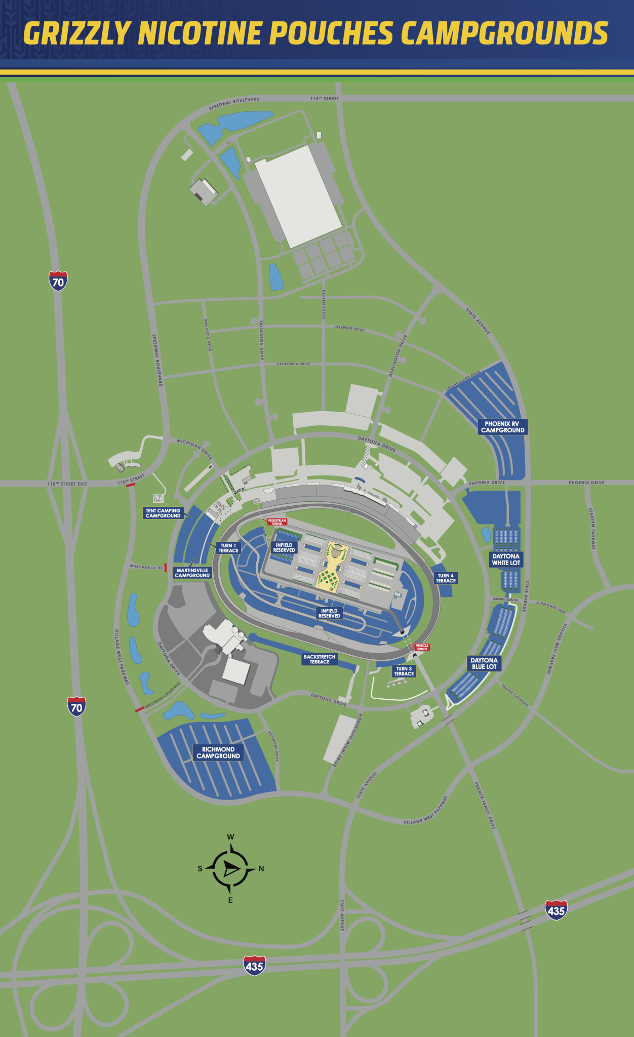
The Kansas Speedway Camping Map provides an overhead view of all designated camping and RV areas surrounding the speedway facility. The map is oriented with north at the top and shows the race track centered within a large network of roads, parking lots, and campgrounds.
General Layout
-
The racetrack is an oval in the center of the map, with the infield marked “Infield Reserved” for premium RV and camping spaces.
-
Multiple campground areas surround the racetrack and are labeled by name and location relative to the track’s turns or major roads.
Campground Locations
-
Infield Reserved – Located within the racetrack oval, offering central access and proximity to all major facilities.
-
Martinsville Campground – Positioned northwest of the track near Chicagoland Drive and Stadium Parkway.
-
Turn 1 Terrace – Located just outside Turn 1 (southwest corner of the track).
-
Richmond Campground – Southwest of the track, near Village West Parkway and Interstate 70.
-
Backstretch Terrace – Along the backstretch (the straightaway on the far side of the oval).
-
Turn 3 Terrace – Located on the southeast curve of the track, near Turn 3.
-
Turn 4 Terrace – Located at the northeast corner, outside Turn 4.
-
Daytona Blue Lot – Northeast of the track, off Daytona Drive.
-
Daytona White Lot – Adjacent to the Daytona Blue Lot, also accessible from Daytona Drive.
-
Phoenix RV Campground – Located on the far east side of the map near Phoenix Drive and State Avenue.
-
Tent Camping Campground – Just southeast of the track, between Turns 3 and 4.
Access and Roads
-
Major highways I-70 and I-435 border the map, with access roads such as Village West Parkway, State Avenue, and Phoenix Drive connecting the camping areas.
-
The map includes roads labeled Talladega Drive, Watkins Glen Drive, Darlington Drive, and others for orientation.
Additional Features
-
A Pedestrian Tunnel and Vehicle Tunnel provide access to the infield.
-
Hollywood Casino is visible southeast of the racetrack, near the Turn 4 area.
-
Gate D is located near the Backstretch Terrace.
